


Insano
Wednesday, 21 April 2010 22:42
[PPC] BasicGPS
![[PPC] BasicGPS](/media/k2/items/cache/0d0c19531d6e29f793ed165732978408_Generic.jpg)
BasicGPS
Licença: Freeware
Link: basicgps.co.uk
- Code:
Features:
- Provides Spoken Directions (range and bearing) from your location to the selected cache.
- Imports cache files in GPX or LOC format from www.geocaching.com (including pocket queries)
- Realtime cache 'Radar' shows your location and that of the cache for quicker finds.
- Displays Distances and Altitudes in Miles/Feet, Kilometers/Meters or NM/Feet
- Displays Coordinates in Degrees, Minutes or Decimal Degrees format.
- Check your location online with GoogleMaps: See your approx. location and the cache site.
- Works with Built-in or External GPS Modules via the MS Intermediate Driver.
- Displays the cache info from GPX files - including hints.
- Very Simple to use: Just point the Compass arrow at the blue box till you reach the cache!
- Allows you to mark a cache as 'Found' or 'Not Found'
- Displays Full Cache Name and 'GC' Code on Search Screen.
- Plays Audio Warning when no Valid GPS Fix is available.
- Fix added for European users with Decimal Separator Issues.
- A new 'Delete All' function to clear all cache data in one go.
- Export Current Position as LOC File.
- Various Enhancements to the 'All Caches' Screen.
- Now Supports European and Asian character fonts.
- GPX Data Screen Shows Cache Name/Code/Type/Difficulty/Terrian/Full Decscription and Hints.
- Limited Support for Nav Keys Added.
- Automatic 60 Second Refresh on Map Screen Update Added.
- Direct link from Main Screen to GPX View Screen added.
- Fix for 'Near Meridian' Issue ('NaN' value reported) Implemented.
- Simple Compass Display Implemeted.
- Silence GPS Warnings Audio.
- Displays Finder Log entries in GPX files.
- Altitude Label Fix for 320x320 Display Handsets.
- Map Page Auto-Update set to 90 Secs.
- PDA Backlight Menu Setting added for Easier 'Night-Caching' .
- Map Source returned to GoogleMaps..
- Nautical Miles added to Distance Measurement types.
- Fix added for Shutdown issue on slower handsets.
- Cache 'Track line' added to main Compass Display.
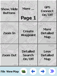
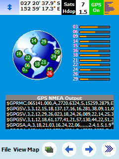
Screenshots:


Published in
Tech
Tagged under
Wednesday, 21 April 2010 22:40
[PPC] OziExplorerCE
![[PPC] OziExplorerCE](/media/k2/items/cache/ba1b7eb9b8ad142948e3b9dce300b4c6_Generic.jpg)
OziExplorerCE
Licença: Shareware
Link: oziexplorer3.com
- Code:
Features:
 *  Uses almost any map which can be created by the PC version of OziExplorer.
 * Moving map navigation using any GPS providing NMEA output in one of the supported sentences.
 * Design the screens used in OziExplorerCE using the PC based designer software.
 * Course Up Mode.
 * 3D Perspective View Mode.
 * Automatic loading of the next map.
 * Automatic Route prompting with user created routes (voice and symbol).
 * Create Route on screen using the stylus.
 * Check for more detailed map at a set interval.
 * 5 user tracks can be loaded
 * Tracks can be created on the map using the stylus
 * Logging of Track points to file.
 * Create Waypoint at current position * Create Waypoints using the Stylus.
 * Drag Map Objects to new position.
 * Many Map Zoom levels.
 * Various Position display formats.
 * On screen display of Speed and Bearing.
 * Speed Monitor (plays sounds (wav files) when set speeds exceeded).
 * Display Waypoints on the map.
 * Find Maps at cursor position.
 * Name Search * Log Book
 * Satellite View * Map View
 * + much, much more.
Screenshots: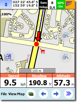
Published in
Tech
Tagged under
Wednesday, 21 April 2010 22:38
[PPC] BeeLineGPS
![[PPC] BeeLineGPS](/media/k2/items/cache/2a14beb1aee2d71c6fecb12f25c690f7_Generic.jpg)
BeeLineGPS
Licença: Shareware
Link: visualgps.com
- Code:
Features:
BeeLineGPS is a high performance Windows Mobile cache navigation and management software tool. Import GPX files and manage thousands of waypoints with the advanced Waypoint Manger. View, manage and hunt geocaches with ease and confidence while having fun, a perfect paperless solution. BeeLineGPS also includes active waypoint technology where a waypoint can trigger a warning window for speed traps, safety cameras or play a sound byte while on a guided tour. Other features include waypoint averaging, altitude profiling and a comprehensive trip computer. BeeLineGPS is the ultimate GPS tool for your geocaching and outdoor needs.

BeeLineGPS waypoint database can support thousands of waypoints with over 120 icons to  depict specific locations. If you don't see a specific icon, ask for it and we'll add it.

 * View Geocache Information as seen in the original website
 * Export tracks to Google Earth XML format (learn more...)
 * Comprehensive Trip Computer
 * Advanced Analysis Plotting
 * Import GPX files with geocaching support
 * Advanced Waypoint Management
Screenshots:


Published in
Tech
Tagged under