


Insano
[Symbian] AFTrack
![[Symbian] AFTrack](/media/k2/items/cache/3707d8f2be163bd14c78cf07586f13bb_Generic.jpg)
O AFTrack é um programa freeware para procurar caixotes entre outras funções e funciona na plantaforma symbian s60 (2ª, 3ª e 5ª geração)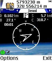
AFTrack is the display for your GPS mouse and activates the world of hiking, biking, sailing, geocaching or more for your phone. The program handles tracking with smart and fixed logging features. It sends reports via GPRS or SMS. It receives SMS position messages and show it as a waypoint. It exports and imports waypoints and routes. And more.
Features:
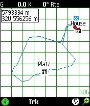
* Six views to the GPS data - position, goto, track summary, map, altitude profile, satellite
* Big diplay
* Tracking the current way
* Export tracks (PCX, IGC with security record (registered at http://www.onlinecontest.org/), KML viewable with Google Earth)
* Import routes from routes or tracks (PCX, GPX, KML, OVL)
* Degree or UTM format
* Edit position in selected output format
* Import JPG, GIF, PNG, BMP, TIFF, GeoTiff or BSB as map - BMP, TIFF, GeoTiff and BSB size can be larger then phone memory
* Calibrate maps with various types
* Automatic calibration from different cal file formats
* Automatic map selection from the map storage
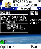
* Waypoint group to organize the waypoints
* Save current position as waypoint
* GoTo a waypoint
* Import waypoints (PCX, Geocache LOC, GPX)
* Export waypoints (PCX, KML)
* Using extra text files for waypoint description (e.g. details of a geocache, groundspeak:long_description is supported)
* Make route from a track
* Makes way points to area
* Reverse routes
* Alarm on reached POIs, anchor alarm
* GPRS position sending
* SMS position sending
* SMS position receiving
* Reset GPS from SIRF to NMEA mode
* Automatic reconnection to GPS if connection lost
* Filter the altitude and speed values with a Kalman filter
* Logging the NMEA sentences
* Long time tracking
* Support for GLONASS satellites (extern gps only)
Mais informação na pagina oficial
[PPC] Wherigo Player
![[PPC] Wherigo Player](/media/k2/items/cache/780149ddfa09fbd86eb140fe6810d770_Generic.jpg)
Wherigo Player
Licença: Freeware
Link: wherigo.com
- Code:
Features:
Wherigo is a toolset for creating and playing GPS-enabled adventures in the real world. Use GPS technology to guide you to physical locations and interact with virtual objects and characters.
Screenshots:

[PPC] Richesse-GPS
![[PPC] Richesse-GPS](/media/k2/items/cache/398a8bc2e3f7f879ff0986359513be80_Generic.jpg)
Richesse-GPS
Licença: Freeware
Link: code.google.com/p/richesse-gps
- Code:
Features:
* Small - RichesseGPS takes about 103 KiB of your PDA memory.
* Hi-DPI aware - RichesseGPS is designed in modern manners, it is ready for VGA displayes.
* Compass - RichesseGPS shows you the distance from the selected cache and the speed you are approaching the cache.
* Import - RichesseGPS can import LOC and GPX file formats (available from geocaching.com). It can also import OV2 files.
* Export - Export your POIs and exchange them with your friends (from 1.1).
* Cache status - You can mark your caches with three states (Not completed, completed, not found).
* GPS Coordinate Format - You can change between three types of GPS coordinates (DD.DDDDDD, DD MM.MMMM, DD MM SS.SS).
* Sorting - You can sort your caches by name or status.
Screenshots: